
Hike Black Dome and Thomas Cole, Saturday, August 12 8:30 AM
Join Siu S Yuen for this difficult 6.5-mile, out-and-back hike to Black Dome (3,980 ft.) and Thomas Cole (3,950 ft.). We'll take the Black 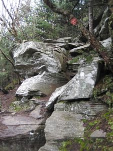 Dome Range trail (red), cross the Batavia Kill, and ascend steeply to the ridgeline with viewpoints. We'll continue on the trail over Black Dome and on to the wooded summit of Thomas Cole. After a pause at Thomas Cole, we'll retrace our steps and break at the viewpoint looking south from Black Dome. From here, we’ll head down the trail and back to our cars.The hike is expected to take five hours. Participants should bring lunch, at least 2 liters of water, snacks, maybe sunscreen, bug spray, and most importantly, sturdy hiking boots. Dogs are not permitted on this hike. Participants must register by 6 p.m. on Friday, 8/11/2023 by contacting Siu S Yuen at ssyuen@msn.com The rain date is Sunday, August 13.DirectionsFrom (Ext 20) in Saugerties, take 32 North for 6 miles, keep straight onto NY-32A / Route 32A for 1.3 miles, keep right to stay on NY-32A / Route 32A for 0.6 miles, bear left onto NY-23A / Route 23A for 5.5 miles, turn right onto County Route 25 / County Hwy-25 for 2.7 miles, bear right onto County Route 23C and stay on it for 4 miles, turn right onto Maplecrest Rd / County Hwy-40 for 1.9 miles, turn right onto County Hwy-56 (Big Hollow Rd) for 4.3 miles until the end and park in lot at the end. Meeting location GPS coordinates: N42.2886 W74.1143.From Exit 20 (Saugerties) NYS Thruway, take NY 32 north for six miles and keep straight onto NY-32A. Take NY-32A for 0.6 miles, bear left onto NY-23A. Take Route 23A for 5.5 miles, turn right onto County Hwy 25. Take County Hwy-25 for 2.7 miles, bear right onto County Route 23C and stay on it for four miles. Turn right onto Maplecrest Rd. (County Hwy 40), go 1.9 miles, then turn right onto County Hwy 56. Take County Hwy 56 (Big Hollow Road) for 4.3 miles until the end. Park in lot at the end of the road. Meeting location GPS coordinates: N42.2886 W74.1143.From NY-23 in Windham, take 23 east to NY-296; turn right on 296 and take 1.5 miles and stay straight (296 goes left) onto Co. Hwy 40 (Maplecrest Rd.) and continue two miles to Maplecrest and turn left onto Co. Hwy 56 (Big Hollow Road) for 4.3 miles until the end. Park in lot at the end of the road. Meeting location GPS coordinates: N42.2886 W74.1143.From NY-23 in East Windham, take 23 west to Co. Hwy 65 and turn left onto 65A. Take 65A, this merges with Co. Hwy. 40, and continue three miles to Maplecrest. turn left onto Co. Hwy 56 (Big Hollow Road) for 4.3 miles until the end. Park in lot at the end of the road. Meeting location GPS coordinates: N42.2886 W74.1143.