
Hike Hunter and Southwest Hunter Mountains – July 22, 8:30 AM
This is a 10-mile strenuous loop hike to SW Hunter (3,750 ft.) and Hunter (4,040 ft.), which is the second highest of the Catskills High Peaks. We'll take the Diamond Notch Trail (blue) to Devil's Path (red) to where we'll have our first view at Geiger's Point. We'll take a herd path to SW Hunter where we'll retrace our steps for a bit, and then we'll continue via the Devil's Path to the summit of Hunter. The fire tower offers outstanding views and there is a nearby viewpoint looking out over Southwest Hunter and beyond. Continuing from Hunter on the Spruceton Trail (blue), we’ll make a short stop at John Robb lean-to and view before we loop out to our cars. 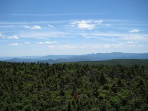
Participants need to bring lunch, at least 2 liters of water, snacks, maybe sunscreen, bug spray, sturdy hiking boots. Pre-registration is required by 6 PM July 21. Please contact leader Siu S Yuen via email ssyuen@msn.com This hike is expected to take seven-eight hours. Dogs are not permitted. The bad weather date is Sunday, July 23.From the traffic circle at Kingston/ Exit 19 NYS Thruway, take NY-28 west for 27.6 miles, turn right onto NY-42 and go 7.3 miles, then turn right onto Spruceton Road/County Highway 6 and go 6.7 miles and park at the first lot on your left (the lot with the horse ramp). (The NY-28/ 42 junction is 3.1 miles east of Big Indian.)From NY-23A go the junction with NY-42 at Lexington; take 42 south for 4.1 miles and turn left on Spruceton Road/County Highway 6. Go 6.7 miles and park at the first lot on your left (the lot with the horse ramp). (The NY-23A/ 42 junction is 6.3 miles east of the junction of NY-23A/ 23 in Prattsville and 7.7 miles west of the junction of NY-23A/ 296 in the village of Hunter.)