
POSTPONED TO 7/23 Hike to Slide Mountain, the Catskills’ Highest Peak, NOW July 23, 9 AM
This 11.2-mile hike, beginning at the Denning Trailhead, offers a chance to take a lesser-traveled route to Slide Mountain. This outing will include 2100’ of elevation gain and is expected to take 8-10 hours. Though rated difficult, the hike will follow marked trails and pass thr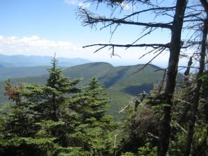 ough a variety of forest types and trailside environments and include some open views.Hikers must register for this event by contacting leader Al Purdy, either by email Albertpurdy1@aol.com or phone (845) 489-2332 by July 21. Space is limited.Participants need to bring lunch, as well as a lot of water, headlamp or flashlight, rain gear, sunscreen, and insect repellent. The ability to filter water would be a plus. Dogs are not permitted. Heavy rain or severe thunderstorms cancels the hike.From the NYS Thruway Exit 19 Kingston, bear right onto State Route 28 West and go 30 miles to Big Indian. Turn left at Big Indian onto Ulster County Route 47 (Oliverea Road) and go south for 20.3 miles. Turn left onto Sullivan County Route 19 (Denning Road); go through the hamlet of Claryville, pass back into Ulster County, and follow this road for 7.7 to the DEC parking area at the end of the road. From Margaretville, turn left onto State Route 28 from Bridge Street and follow for 12.3 miles. Turn right onto Ulster County Route 47 (Oliverea Road), follow for 20.3 miles. Turn left onto Sullivan County Route 19 (Denning Road), pass back into Ulster County, and follow this road for 7.7 to the DEC parking area at the end of the road. GPS Coordinates: N41 57.9545 w74 27.144